
Introduction: The Puzzle of the Static Earth #
Once upon a time, geographers and map-makers believed our Earth was solid, static, and motionless. They thought the continents sat exactly where they were created, like stone statues in a garden. But nature has a way of leaving crumbs for those curious enough to look.
In 1596, a Dutch map-maker named Abraham Ortelius looked at the map of the world and noticed something odd. The bulge of Brazil in South America seemed to fit perfectly into the curve of Africa’s Gulf of Guinea, like a missing piece of a jigsaw puzzle. This observation lay dormant for centuries until a German meteorologist decided to shake the very foundations of geology.
Continental Drift Theory: The Great Breakup #
The Hero: Alfred Wegener (1912) The Setting: 250 Million Years Ago
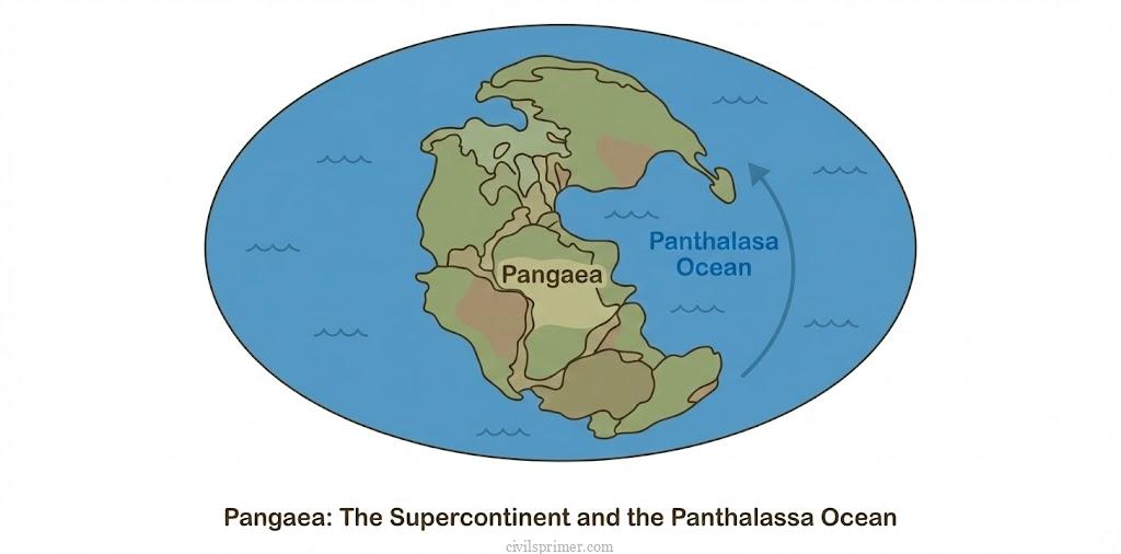
Alfred Wegener wasn’t satisfied with the “static earth” story. He proposed a radical idea: The Continental Drift Theory. He argued that millions of years ago, there wasn’t a “World Map” as we know it. There was just one super-continent named Pangaea (meaning “All Earth”) and one massive mega-ocean surrounding it called Panthalassa (meaning “All Water”).
The Plot Twist: Around 200 million years ago, this massive family of continents began to fight and split up. Pangaea broke into two large blocks:
- Laurasia (The Northern Block)
- Gondwanaland (The Southern Block) Between them, a new sea opened up—the Tethys Sea,.
The Evidence (Wegener’s Defense): Wegener knew people wouldn’t believe him without proof. So, he acted like a lawyer presenting evidence in court:
- The Jigsaw Fit: As Ortelius saw, the shorelines of Africa and South America fit together with remarkable symmetry.
- Rocks of the Same Age: He found ancient rock belts (2,000 million years old) in Brazil that matched perfectly with rocks in Western Africa. It was as if someone had torn a single painting in half.
- Tillite (Glacial) Deposits: He found evidence of ancient glaciers (Tillite) in India, Africa, Falkland Island, Madagascar, Antarctica, and Australia. This proved that these lands, now in hot tropics (like India), were once bundled together near the South Pole.
- Placer Deposits (Gold): Ghana in Africa had rich gold deposits but no source rocks (gold veins). The source rocks were found across the ocean in Brazil!.
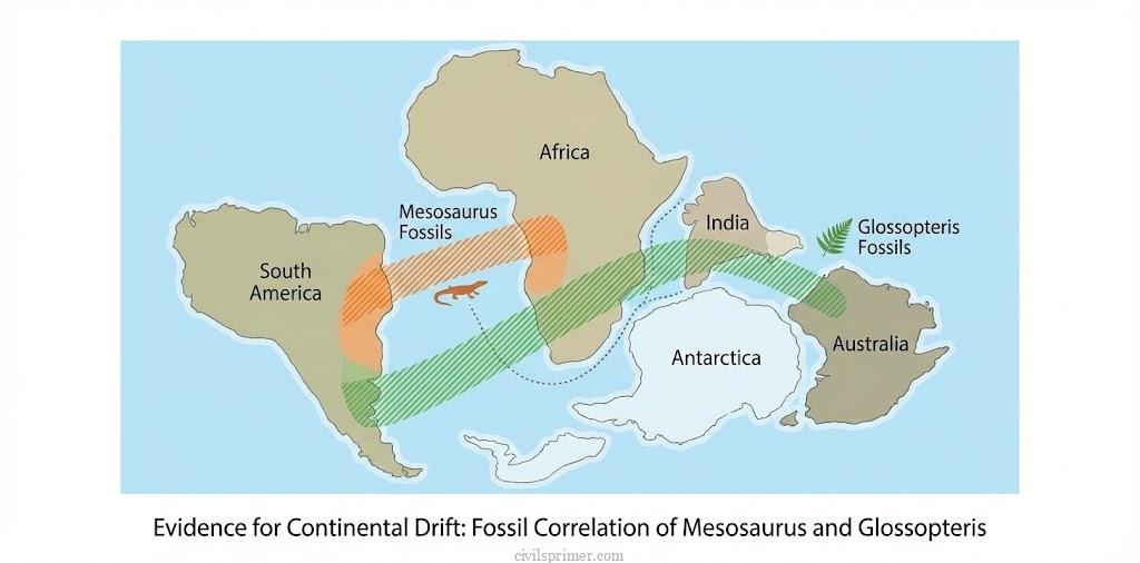
- Fossils: He found fossils of a small reptile, Mesosaurus, which could not swim across an ocean. Yet, its skeletons were found only in South Africa and Brazil. Similarly, the vegetation Glossopteris was found across India, Africa, and Antarctica.
The Cliffhanger (The Flaw): Wegener proved the continents moved, but he couldn’t explain how. He guessed it was the Pole-Fleeing Force (due to Earth’s rotation) or Tidal Force (attraction of the Moon/Sun). However, scientists calculated that these forces were too weak to drag massive continents. Wegener’s theory was dismissed, but the seed was planted.
Convection Current Theory: The Boiling Pot #
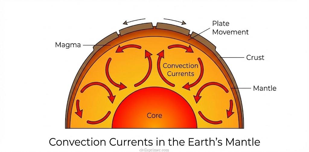
While Wegener was ridiculed, Arthur Holmes (1930s) looked deeper—literally. He looked into the Mantle. Holmes suggested that the Earth is like a boiling pot of thick soup. Radioactive elements deep inside generate immense heat, creating Convection Currents. Imagine rising columns of hot magma. When they hit the bottom of the crust, they spread out, dragging the crust with them. This was the missing engine that Wegener failed to find. These currents could split continents apart and push them around.
Sea Floor Spreading: The Ocean Floor is Alive #
World War II brought new technology like sonar, which allowed us to map the ocean floor. Scientists were shocked. The ocean floor wasn’t a flat sandy plain; it was full of massive mountain ranges (Ridges) and deep valleys (Trenches). Harry Hess (1961) put the pieces together in the Sea Floor Spreading Theory.
1. The Factory: Along the Mid-Oceanic Ridges, volcanoes constantly erupt.
2. The Conveyor Belt: New lava pushes up, solidifies, and pushes the old floor sideways. This means the ocean floor is constantly spreading and creating new crust.
3. The Graveyard: If new crust is being made, the earth should be getting bigger. But it isn’t. Why? Because at the Trenches, the ocean floor sinks back into the mantle and is destroyed (subduction).
The Smoking Gun (Paleomagnetism): The strongest proof came from magnets. The Earth’s magnetic field flips every few million years (North becomes South). The rocks on the ocean floor recorded these flips like a barcode. This Paleomagnetism proved that rocks near the ridges were young and normal, while rocks further away were older and had reversed polarity.
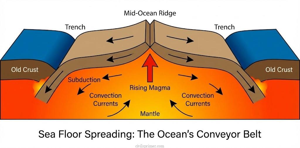
Plate Tectonics: The Grand Unified Theory #
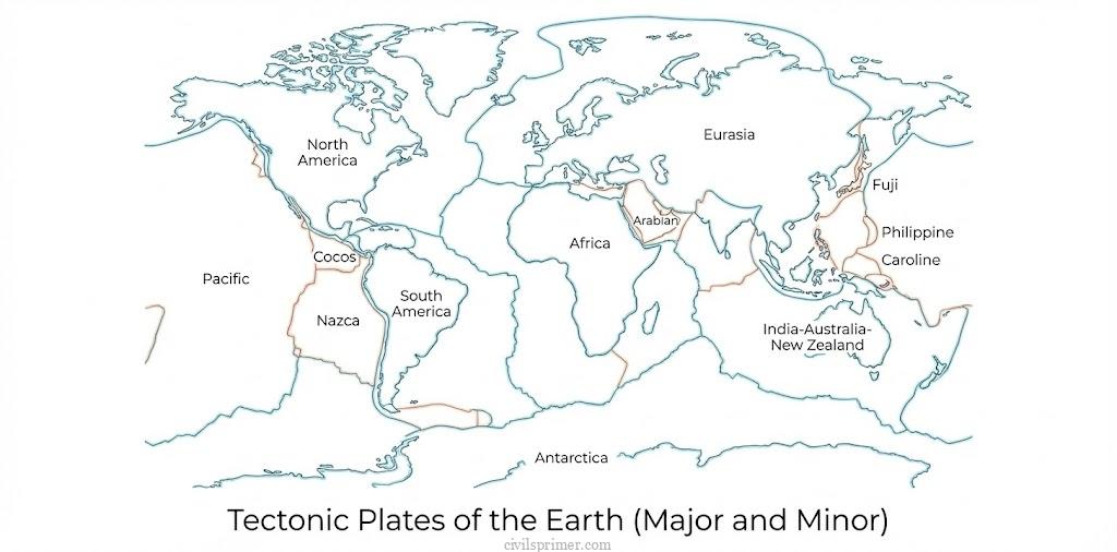
Finally, scientists McKenzie, Parker, and Morgan (1967) combined Wegener’s Drift, Holmes’ Currents, and Hess’ Spreading into one master theory: Plate Tectonics | The Concept: The Earth’s outer shell (Lithosphere) is not one piece. It is cracked into broken plates, like a cracked eggshell. These plates float on the semi-molten layer called the Asthenosphere. The Plates:
- Major Plates: Antarctica, North America, South America, Pacific (mostly oceanic), India-Australia-New Zealand, Africa, Eurasia.
- Minor Plates: Cocos, Nazca, Arabian, Philippine, Caroline, Fuji, etc.
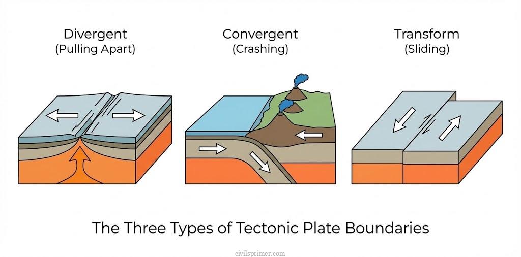
The Interaction (Boundaries): The plates are constantly moving. Their interactions shape our world:
- Divergent Boundaries (The Breakup): Plates move apart. Magma rises. New crust is born.
- Result: Mid-Atlantic Ridge, East African Rift Valley.
- Convergent Boundaries (The Crash): Plates collide.
- Ocean-Ocean: One sinks, creating volcanic islands (e.g., Japan, Philippines).
- Ocean-Continent: The heavy ocean plate dives under the lighter continent. This creates volcanoes and mountains (e.g., Andes, Rockies).
- Continent-Continent: Both are too light to sink. They crumple and rise, creating massive Fold Mountains (e.g., Himalayas).
- Transform Boundaries (The Slide): Plates slide past each other. Crust is neither created nor destroyed, but it shakes violently.
- Result: San Andreas Fault (Earthquakes).
The Journey of India #
Let’s focus on our home. Millions of years ago, India was a large island located off the coast of Australia, near the South Pole!
1. The Race North: About 70 million years ago, India separated and started racing north towards Asia at a rapid speed.
2. The Fire: On its way, it passed over a hot volcanic area (Reunion Hotspot), which poured massive amounts of lava, creating the Deccan Traps (Maharashtra plateau).
3. The Collision: About 40-50 million years ago, India crashed into the Eurasian plate. The Tethys Sea was squeezed shut.
4. The Rise: The sediments of the sea were pushed up to form the Himalayas. India is still pushing north, which is why the Himalayas are still rising and why we have earthquakes in the north.
And thus, the dynamic dance of the earth continues, shaping the mountains, oceans, and lands we live on today.
UPSC Prelims Pointers #
- Evidence of Drift: Remember “Jig-Saw Fit” (South America & Africa), “Tillite” (Glacial deposits in non-polar regions), and “Placer Deposits” (Gold in Ghana, veins in Brazil),,.
- Forces: Wegener proposed Polar Fleeing Force (Rotation) and Tidal Force. Both were proven inadequate. Modern theory relies on Convection Currents,.
- Plate Composition: The Pacific Plate is largely oceanic. The Eurasian Plate is largely continental.
- Indian Plate Boundaries:
◦ North: Convergent (Himalayas).
◦ East: Spreading site (Pacific) / Convergent (Myanmar).
◦ West: Kirthar Mountain (Pakistan) and Makrana Coast. - Ring of Fire: Circum-Pacific belt associated with deep earthquake zones and active volcanoes due to subduction.
- Paleomagnetism: It is the study of magnetic fields recorded in rocks and is the primary evidence for Sea Floor Spreading.
UPSC Mains Subjective Previous Years Questions #
- 2019 → Define mantle plume and explain its role in plate tectonics.
- 2013 → What do you understand by the theory of continental drift? Discuss the prominent evidence in its support.
Answer Writing Minors #
Introduction (3-4 Lines):
“The geomorphological evolution of the Earth’s surface is best explained through the transition from Alfred Wegener’s Continental Drift Theory to the comprehensive Theory of Plate Tectonics. These theories elucidate that the Lithosphere is not static but a dynamic mosaic of moving plates driven by endogenic forces like mantle convection currents.”
Conclusion (3-4 Lines):
“Conclusively, the interactions at plate boundaries—divergent, convergent, and transform—are the primary architects of the Earth’s relief features, including Fold Mountains, oceanic ridges, and trenches. Understanding these tectonic mechanisms is crucial for comprehending geophysical phenomena like seismicity, volcanism, and the distribution of mineral resources globally.”
Related Latest Current Affairs #
- November, 2025: Delamination of the Indian Plate Recent studies analyzing seismic data from the Hindu Kush-Himalaya region revealed that the Indian Plate is not merely subducting but splitting horizontally. This process, known as “Delamination,” involves the lower part of the Indian Lithosphere peeling away and sinking into the mantle, creating intense tectonic stress and frequent earthquakes along the collision zone.
- November, 2025: Eruption of Hayli Gubbi Volcano in the Afar Triple Junction The Hayli Gubbi volcano in Ethiopia erupted after nearly 10,000 years. It is located in the Afar Depression, a geologically unique “Triple Junction” where three tectonic plates—the Nubian, Somali, and Arabian—are diverging (moving apart), showcasing active continental rifting that is slowly splitting Africa to form a new ocean basin.
- November, 2025: India’s Exploration Contract for Carlsberg Ridge India secured a contract from the International Seabed Authority (ISA) to explore Polymetallic Sulphides in the Carlsberg Ridge. This ridge is a Divergent Plate Boundary in the Indian Ocean formed by Sea Floor Spreading, where the African, Indian, and Australian plates move apart, allowing magma to rise and create new Oceanic Crust.
- August, 2025: Renewed Volcanic Activity at Axial Seamount Scientists reported renewed activity at the Axial Seamount, an underwater volcano located on the Juan de Fuca Ridge off the US coast. This site lies along a spreading center (mid-ocean ridge) where the Juan de Fuca Plate diverges from the Pacific Plate, offering real-time insights into the process of Sea Floor Spreading and the creation of new Oceanic Crust.
- May, 2025: Geological History of the Red Sea Rifting New research revealed that the Red Sea, a young ocean basin formed by the rifting of the African and Arabian tectonic plates, completely dried up about 6.2 million years ago. The Red Sea represents an active example of Continental Drift and plate divergence, where a rift Valley is widening into an ocean.
- May, 2025: Subduction Zone Volcanism at Mount Lewotobi Laki-laki The eruption of Mount Lewotobi Laki-laki in Indonesia highlighted the intense tectonic activity along the Sunda-Banda Arc. This stratovolcano was formed by the subduction of the Indo-Australian Plate beneath the Eurasian Plate, a classic example of Plate Tectonics at a convergent boundary.
- December, 2024: Tectonic Integration along the Denali Fault Research identified that three distinct geologic sites along the Denali Fault (Alaska/Canada) were once a single feature, separated by 300 miles of horizontal movement. This strike-slip faulting is driven by the Plate Tectonic interaction of the Pacific Plate subducting beneath the North American Plate, integrating landmasses over millions of years.
- December, 2024: Imaging of Hydrothermal Vents in the Indian Ocean Indian oceanographers captured images of active hydrothermal vents 4,500 meters deep in the Indian Ocean. These vents are key features of Sea Floor Spreading centers found near tectonic plate boundaries and ridges, where seawater interacts with magma from the mantle to form mineral-rich plumes.